Mobile network coverage maps have been a useful tool for depicting availability of 2G to 5G mobile services in different locations. Typically, these maps have been used to show mobile coverage in two dimensions (2D), as shown for instance in this map repository maintained by GSMA. These 2D are created by different approaches, including, walk or drive tests, crowdsourced data and radio proparation modelling tools.
The recent trend of unmanned aerial vehicles (UAVs) or drones utilising mobile network connectivity to relay high resolution aerial imagery has necessitated similar coverage to also depict network coverage in the sky, thus underscoring need for 3D coverage maps. As part of PriMO-5G experimentals activities, researchers at Yonsei University have used drone flight tests to construct 3D coverage maps of a local 5G testbed. The results of this work was presented at the 26th Annual International Conference on Mobile Computing and Networking, in September 2020. You are invited to view the presentation of the work via the following YouTube link.
Full paper here: https://dl.acm.org/doi/10.1145/3372224.3418160
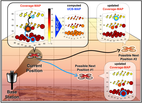
Algorithm-driven development of 3D coverage maps using drones

